Table of Contents
- Manifestations of Faith
- “Don’t tempt the Babylonian numerology”: Horace, Ode I. 11
- “This I will seale with my blood”: The Execution of William Leddra
- These are the Great Instruments of Providence
- Recent Acquisitions — Winter-Spring 2022
- Developments — Winter/Spring 2022
- Announcements — Winter/Spring 2022
Recent Acquisitions — Winter-Spring 2022
Book Division
This newly-acquired volume includes wonderful leaves of publishers’ advertisements in the back of the book. The publisher claims that he has a large collection of books, over 50,000 in stock, on a wide variety of subject matter that are available for purchase, including many scarce and valuable books. He also advertises his paper mill, which is able to supply paper of any quality. In addition, he offers cash for linen, cotton rags, wholesale cloth, and junk. Altogether, this provides an interesting glimpse into the economics of bookselling and papermaking at a particular moment in New York history. “He does bookbinding with neatness and reasonable prices and also job printing of all kinds, executed at moderate rates”—an all-in-one business model. A notable feature of this particular copy is that it is bound in contemporary paper over scale board with a hand-sewn leather overcover. It includes ownership inscriptions from Jacob and Lydia Garretson, and then “a present to Phebe Angeline Walker 1851” in the back of the book, with cloth flowers tucked into the binding, a lovely example of repair and continued use of the book long after it was printed.
The Carrier Dove, a Spiritualist newspaper published in San Francisco and edited by two women, Elizabeth Lowe Watson (1843-1927) and Julia Schlesinger (1847-1929).
A publication with a feminist perspective, the Carrier Dove adds to our growing materials on Spiritualism. It includes articles on topics such as women in journalism, reporting that “Progressive newspaper makers are fast realizing the fact that some of the ablest and most earnest workers in journalism are women. A few years ago, a woman novelist was regarded as something of a curiosity and a woman journalist as little less than a monstrosity. Time has abundantly demonstrated the fact that a woman can earn her living with her pen and still preserve her womanliness and she can put a snap, a go, a delicacy in her work which few men can imitate.” There is more reading to be done in this volume on many Spiritualist and feminist topics. The Clements also recently acquired a volume of biographies of Spiritualists written and edited by Julia Schlesinger.
Manuscripts Division
Le Maire Family Papers, 1785-1854. 339 Manuscripts.
This collection contains upwards of 300 letters and documents pertinent to the Haitian Revolution and will serve as a support and expansion of our representation of the conflict and its aftermath. The Le Maire family of Dunkirk on the northern coastline of France owned a coffee and cocoa plantation near Jérémie, St. Domingue (Haiti), and the collection includes rich correspondence during the two years leading up to the 1791 uprising of enslaved persons, a few letters during the conflict, and letters from France discussing the conclusion of the conflict. These papers are a striking addition to our West Indies collections particularly for the documentation of the Haitian Revolution from a French planter’s perspective. Following the revolution, the French government negotiated to recognize the new Haitian government, but in return demanded that the Haitians pay reparations for lost property, including the property embodied in formerly enslaved persons. Paperwork regarding these reparations forms the core of the Le Maire Family Papers.
Cuba Collection, 1830-1893. 68 Manuscripts and growing.
The Cuba Collection consists of recently acquired items merged with several pre-existing items from the Clements holdings. This combined collection represents our efforts toward documenting selected aspects of Cuban history within the parameters of realistic acquisition opportunities, needs of researchers, and teaching methods. We will continue to add new materials to the collection moving forward.
The collection currently relates to aspects of the economic, racial, and political history of the island in the 19th century. It especially documents the indentured servitude of Chinese workers, as well as Cuba’s enslavement and manumission of largely African people. Other items pertain to insurrections and filibusters on the island, including pieces related to the Lopez Expedition and the Cuban independence conflicts of 1868-1878. Also present are examples of passports for the transfer of slaves from one plantation to another, insurance policies on individual enslaved persons, slave auction records, manumission documents, various examples of contracts for Chinese indentured servitude, other Chinese immigration documents and railroad labor paperwork, citizenship and death certificates, and more.
One notable item is a sewn body of 21 letters documenting military actions and plans of Cuban revolutionaries in 1870, particularly the correspondence of revolutionary Miguel de Aldama, a wealthy Cuban aristocrat who became president of the Cuban Junta in New York.
Graphics Division
[Portrait of Long Otter], by Richard Throssel.
A striking portrait of Long Otter (mis-titled Long Otto) has joined the Clements collections. Taken by Richard Throssel (1882-1933), a photographer of Native American descent, the platinum print shows Long Otter of the Crow Indians wearing a headdress topped with what appears to be a golden eagle. This exciting and unusual photograph, where both creator and subject were Native Americans, will be added to the Richard Pohrt, Jr. Collection of Native American Photography.
Also new to the Graphics Division are two cabinet photographs of students who attended the United States Indian Industrial Training School (known as the Haskell Indian School and currently in existence as the Haskell Indian Nations University), a boarding school for Native Americans started in Lawrence, Kansas, in 1884. The only identified individual is Robert Agosa, who was Ojibwe and whose grandfather was a tribal leader. Agosa went on to become a prominent tailor in the Traverse City area.
Map Division
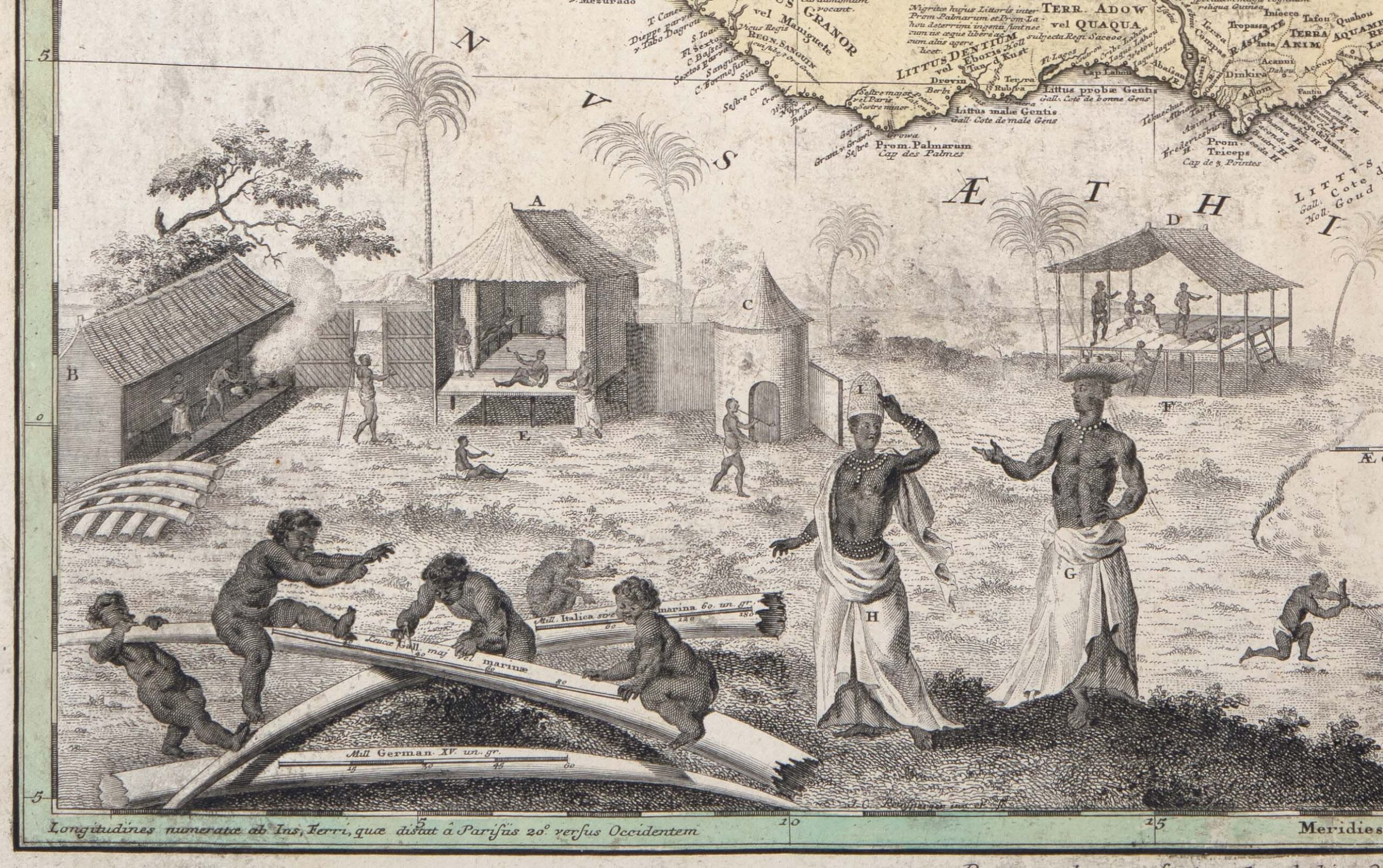
Detail from Guinea propria, nec non Nigritiae vel Terrae Nigrorum maxima pars, geographis hodiernis dicta utraq . . . ([Nuremberg], 1743).
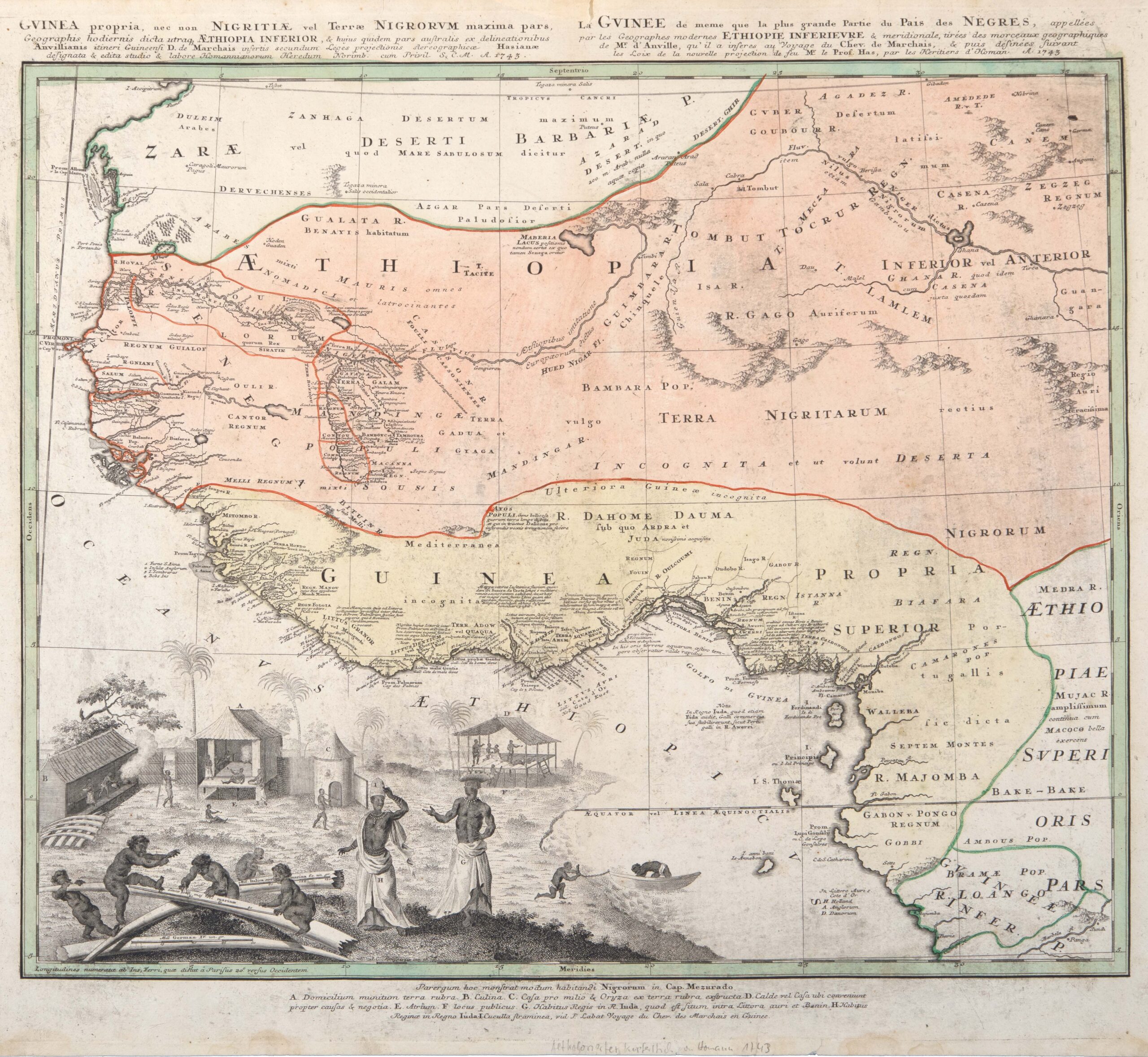
Guinea propria, nec non Nigritiae vel Terrae Nigrorum maxima pars, geographis hodiernis dicta utraq . . . [Guinea itself as well as Nigritia or the greatest part of the Land of the Blacks as told by today’s geographers…] ([Nuremberg], 1743).
The long full title in Latin and its French equivalent at the top of this highly detailed map tells us much about the sources of this depiction of the coast and interior of the West African region now known as the sub-Sahara. Many notes in Latin populate this map of northwest Africa and its coastline, providing a wealth of detail about trade opportunities, local people, and geographic features. A lettering system of F. H. A. or D. is used to indicate which Europeans (French, Dutch, English, or Danes) held coastal trading posts or factories, used as clearing houses for trade goods and human beings destined for transport in the Trans-Atlantic slave trade. At the same time, African kingdoms which controlled the coast and the near interior are also labeled and described. A detailed and evocative illustration in the lower left describes visually the way of life of locals in Cap Mezurado (on the coast of what is now Liberia)—house, kitchen, milling works, meeting house—and the style of dress of the king and queen of Juda, on the Gold Coast in what is now Benin. These sympathetic depictions and the geography are based, according to the title, on the travels of the chevalier Des Marchais (d. 1728) in the region from 1725-27, described and published by Jean Baptise Labat (1663-1738), in Voyage du chevalier Des Marchais en Guinée (Paris, 1730) with maps by the French geographer, J.B.B. d’Anville (1697-1782). The Latin/French map was compiled from these sources by the German geographer, Johann Matthias Hase (1684-1742), who used a new projection of his own devising, and published by the Nuremberg map firm, Homann Heirs, in 1743. Thus the map represents the result of on-site observations and leaves blank what is unknown. The map is an important connection to other Clements material on the centuries-long trade in enslaved people.
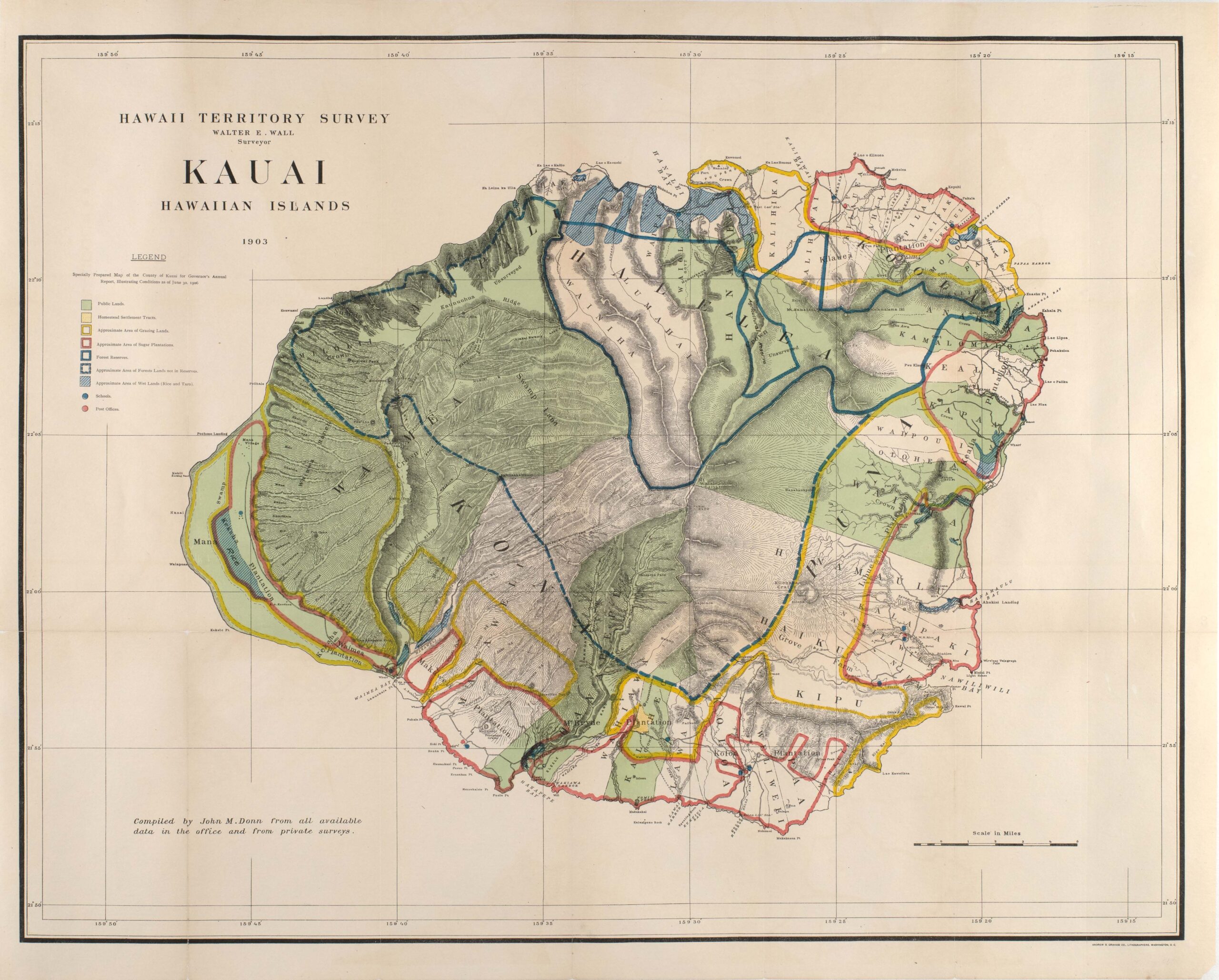
Kauai, Hawaiian Islands, by Walter E. Wall, surveyor (Washington, D.C., 1903).
This map of Kauai is one of a set of maps of the Hawaiian Islands recently acquired for the Map Division. Surveys of the Islands were begun by the Hawaiian monarchy in the 1870s. After the United States-backed overthrow of the monarchy in 1893 and annexation of the islands in 1898, new maps were issued based on these surveys, in the time-honored tradition of an imperial power claiming its territory. Published by the United States Department of the Interior, they focus on arable land and the exploitation of natural resources, containing information on pineapple and sugar plantations, forest lands and reserves, grazing lands and wetlands, public lands and homestead settlement plots. Although the Clements collections are not currently strong in Hawaiian material, the acquisition of these beautiful maps may spark reflection and conversation on the commercially-driven land grab that evolved into statehood for Hawaii in 1959. The maps now at the Clements include Niihau, Maui, Lanai, Kauai, and Molokai; the set lacks Oahu and the Big Island, which we continue to seek.
Director’s Choice
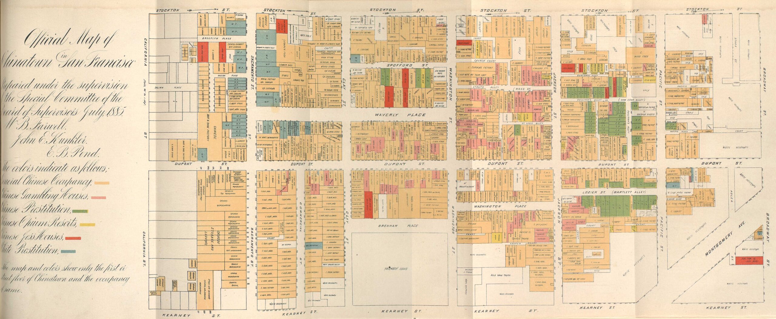
Official Map of Chinatown in San Francisco (San Francisco, 1884-85).
Paul Erickson has an abiding interest in adding to the Clements Library’s strengths in 19th century crimes and associated material. To broaden the collection, he recently acquired an interesting new item on the subject of local crime. This map of Chinatown in San Francisco from a municipal report of 1884-85 depicts the area as a vice district, marking houses of prostitution, gambling houses, and opium dens. Produced two years after the Chinese Exclusion Act was passed, this is a fascinating cartographic example of criminalizing race, by presenting the densest settlement of Chinese immigrants in San Francisco as the epicenter of criminal activity, even though crime was taking place all over the city. It is a great example of how a majority white community defined crime racially and how it used perceived differences to create boundaries defining communities.
Another crime-related addition is a photograph from a notorious serial murder case at the turn of the 20th century. This is a real photo postcard from the investigation taking place on the Indiana farm of Belle Gunness (1859-1908?), a Norwegian immigrant who settled in Illinois and then Indiana. Gunness’ victims included several children who died under mysterious circumstances in addition to at least 14 men lured to her farm in answer to an advertisement for a husband, instead being robbed and bludgeoned.
Trial of A.B. Hillmantle, (Hartman, Arkansas, [ca. 1880]).
Ephemeral items reflect passing cultural obsessions in creative ways, and this broadside uses the trope of crime and punishment to advertise the dry goods store of A.B. Hillmantle, who was “convicted” of selling clothes at low prices. Each juror found him guilty on all counts of providing quality goods at reasonable prices and having the widest selection of clothes available in Hartman, Arkansas. Due to the thinness of the paper, it’s a miracle it has survived, but it now has a safe resting place at the Clements.
- Manifestations of Faith
- “Don’t tempt the Babylonian numerology”: Horace, Ode I. 11
- “This I will seale with my blood”: The Execution of William Leddra
- These are the Great Instruments of Providence
- Recent Acquisitions — Winter-Spring 2022
- Developments — Winter/Spring 2022
- Announcements — Winter/Spring 2022


