To create a digital archive is an expensive endeavor. The Clements Library is deeply committed to sharing its rich collections with an ever-wider audience, but the queue of material is long and resources limited. Pockets of the collection would not see cyber-light were it not for the helpful boost that a donor can provide. We are particularly grateful for support from California map dealer Barry Ruderman, who has provided the funds for the continued digitizing of manuscript maps in the Clements collection.

A scanning project, funded through the support of Barry Lawrence Ruderman Antique Maps, started in March 2019 and was completed in October of the same year. The general scope of the project was manuscript maps created before 1820. We appreciate that the Stephen S. Clark Map Library (in the next door Graduate Library) kindly permitted us to use their large scanner one day a week for the duration of the project. Digitization Technician Kelly Powers performed the bulk of the scanning, with assistance from our Joyce Bonk Fellow Corey Schmidt. A total of 570 manuscript maps were scanned in this project, 197 of which relate to the American Revolution, including maps associated with the manuscript papers of General Thomas Gage, Jeffery Amherst, and George Sackville Germain. These maps, when added to the previously scanned small maps from the collection of Sir Henry Clinton, provide readers with 314 manuscript maps related to the Revolutionary War in the Image Bank. (There are 1768 maps total in the “Maps shelf” category.)
Barry’s appreciation of the power of the digital image is rooted in his own website (raremaps.com) which offers high-resolution images not only of the maps he currently has in stock but also maps that have traveled through his hands in the past. This resource offers map scholars a chance to study maps that may not have entered public collections, and his team’s emphasis on in-depth research to describe their stock adds considerable value to their archive. He has supported scholarly endeavors by providing high-resolution images for publication at no cost. Now he extends similar generosity by helping make the manuscript maps in the Clements collection available to the world.
In recent years, researchers have become increasingly accustomed to search for, find, and click on zoomable images of maps, such as those Ruderman provides online. These high-resolution reproductions of often fragile and rare documents have allowed us access to materials that a mere ten or twenty years ago would require an expensive trip to a library or archive or private collection, with perhaps only limited time to spend with them, and often with no photography allowed. Now our cell phones and personal computers have become virtual private libraries with ever-growing map collections.

Yet spare a thought for how these digital reproductions were made. Behind every image on the screen are curators and technicians who carefully handled each map, placed it on a scanner, adjusted lights and camera settings, accounted for color gradations, prepared the image for secure storage, and created the additional information that identifies all aspects of the map (author, title, date, coverage, context) that make it findable on the web. The costs of digital projects include not only the prodigious price of high-quality scanning machines but more importantly the time and effort of human beings who run them and who curate the metadata.
While military maps demonstrating strategic aspects of the events before, during, and after the American Revolution are always of interest, there are several other types of manuscript maps that provide some insight on American culture and society of the late eighteenth and early nineteenth centuries. Some specific examples will give the reader an idea of the range of material in the collection:
Plan de l’Isle de Martinique, ca 1760
This French map displays a strategic island retained by the French at the end of the Seven Years’ War (Treaty of Paris, 1763), when they lost Canada or New France, but kept a small toe-hold on the north American continent in four islands: St. Pierre and Miquelon near Newfoundland, and Guadeloupe and Martinique in the Caribbean.

Student map Double Hemisphere World map
This example embodies a teaching technique very popular in secondary school academies in the United States in the early 19th century – map copying. The highly decorative nature of this unsigned example suggests it was created as a culminating project or for presentation by a young student.

Map of Great Lot #2 in Sullivan County New York
The Baldwin collection in the Map Division includes large scale property and planning maps by a family of engineers in Woburn, Massachusetts. Their maps reflect the growing urban and rural development and infrastructure in the United States after the Revolution. This plan shows lots with names of proprietors and acreages.

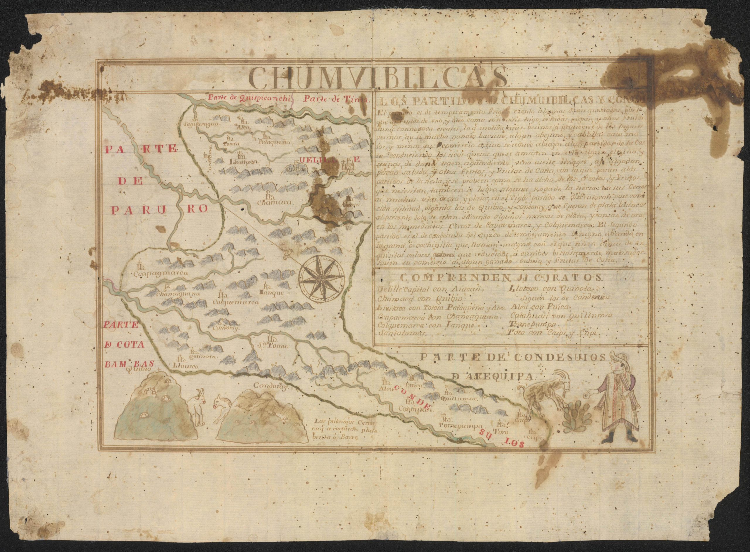
Chumvibilcas. ca 1786
Chumvibilcas was a province in 18th century colonial Peru; this map is one of five manuscript maps made of different provinces with information on the natural resources of the area, in this case the silver mines. They also reflect the mapping style of the Franciscan missionaries in Lima who taught indigenous peoples.
Plan de l’Habitation de Monsieur de La Porte-Lalanne Située au Quartier du Cul-de-Sac Dépendence du Port-au-Prince, 1753
This property map of a sugar plantation in modern Haiti, 18th century French Saint Domingue, ca. 1753 shows the owner’s house and formal gardens, sugar cane fields, slave quarters, sugar storage and processing buildings, cooperage, hospital, distillery, and neighboring property holders.
***
The Clements Library thanks Barry Lawrence Ruderman Antique Maps for the generous donation that has allowed these 570 manuscript maps to be more easily accessed and better preserved. To join us in furthering the Clements’ electronic initiatives, please consider making a gift to the Technology Fund.
— Mary Pedley
Assistant Curator of Maps
