Post by Brian L. Dunnigan, Associate Director and Curator of Maps
Early in the morning of July 17, 1812, the residents of Mackinac Island awoke to pounding on their doors. A group of fellow citizens, led by local militia captain Michael Dousman, told everyone that war had been declared and, unbeknownst to the 61-man US garrison in Fort Mackinac, 600 British soldiers, Canadian voyageurs, and Indian warriors had landed on the island. The British had detained Dousman the day before and, after he promised not to warn the fort, their commander allowed him to gather the villagers in the town distillery, where they could be protected by a guard of British soldiers. The citizens followed his advice, and the town below Fort Mackinac was soon deserted.
 |
|
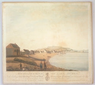
Michilimackinac on Lake Huron was dedicated to the British commander-in-chief in Canada, Sir George Prevost.
|
The British had indeed landed. While the American soldiers in Fort Mackinac were unaware that their country had declared war against Great Britain on June 18, the British commandant of Fort St. Joseph, Captain Charles Roberts, had received the news. He immediately gathered his 45 redcoats, all the voyageurs he could find (300 or so), and 300 Native Americans who had come to trade. They rowed the roughly 50 miles from St, Joseph to Mackinac, where they landed around 3:00 a.m. on July 17. The next few hours were spent dragging a six-pounder cannon for two miles to rising ground behind the fort. Roberts then called on the Americans to surrender in the name of His Britannic Majesty.
Lieutenant Porter Hanks and his men were taken completely by surprise. They manned their guns but the situation was grim. The British cannon could fire into Fort Mackinac, the garrison was outnumbered 10 to 1, and the fort’s water supply was outside the walls. Captain Roberts further hinted that he might not be able to control his Indian allies once fighting began. Hanks had no choice but to surrender. The British would hold the place for the next three years.
 |
|
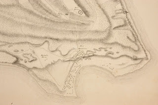
This detail of the 1817 Eveleth map focuses on Fort Mackinac, the town, and harbor. The British placed their cannon on the first or second rise in the ground behind the fort.
|
The British capture of Fort Mackinac was the first significant land action of the War of 1812. The bicentennial of that event is upon us, and, not surprisingly the Clements has a number of items that relate to the incident. One is a celebratory print titled Michilimackinac on Lake Huron. Based on a drawing by Richard Dillon, Jr. and published in Montréal in 1813, the print shows the place as it was in July 1812. A second piece is a remarkably detailed topographical map of Mackinac Island by William S. Eveleth. Although drawn in 1817, the place had not changed over the past five years, and the landmarks of 1812—fort, British position, town, and roads—are shown very clearly. The War of 1812 is a great strength of the Library, and it is appropriate that its first major land action is well represented.
