Here at the Clements Library, we are sometimes asked, “What is your favorite item in the collection?” In a library full of great treasures, there is no easy answer to this question, and the answer will probably vary for each person. Starting with this post, the Clements Library blog will occasionally feature one of these favorite items, selected by a library staff member. These may not always be the most famous objects in the library, but the choices will reveal something of what we do here at the library and why we find this work so rewarding.
Library director Kevin Graffagnino came to the Clements Library from his home state of Vermont. As he often says, his favorite item in the collection is this 1780 map by Bernard Romans, which hangs on the wall of his office. In his book The Shaping of Vermont, Kevin describes its significance:
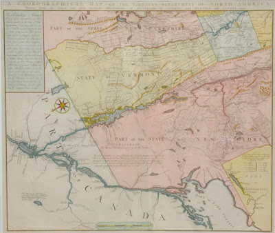
“In the furious war of words that marked the early years of Vermont’s independence, Bernard Romans’s “Choreographical Map of the Northern Department of North-America” was a unique and impressive piece of propaganda for the supporters of the fledgling republic. As the first printed map to display the words “State of Vermont” for the area between the Hudson and Connecticut Rivers, Romans’s work added something to the air of legitimacy that the beleaguered Green Mountain State’s leaders were trying to establish for their new creation. Although the map also included parts of Canada, New York, New Hampshire and Massachusetts, Romans’s emphasis was on Vermont, and to contemporary outsiders interested in the twists and turns of American developments during the Revolution, his map probably spoke as persuasively on the Vermont situation as any pamphlet or broadside from the pen of Ira Allen.”