It seems as if the Director and curators of the Clements Library are always searching—searching for new documentation to make accessible to scholars; searching for collections or parts of collections that they know or hope are still “out there” in the hands of descendants, local and national Americana dealers, or private collectors. To this end the curators carefully examine dozens of catalogs each month and make recommendations to the Director, who then decides what we can afford. All this suggests that much is still available “out there.”
And then there are in-kind gifts, most often donated by descendants of the original writer. The Manuscripts Division has been especially lucky in this category over the last three years, accepting gifts of documents from families to flesh out some of our existing collections—Perry, Douglass, Weld-Grimké and others.
But best of all is the thrill of serendipity—when the right individuals come together in a successful acquisition effort of an item they were not looking for because they were not aware of its existence.
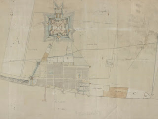
This spring the Map Division was the beneficiary of a good strong shot of serendipity. Map curator Brian Dunnigan received an email from an old friend and colleague, Canadian military historian Donald Graves. Don forwarded rough images with his message. It took just a moment to realize that these depicted a plan of Detroit in 1790 that was entirely unknown, drawn from an unknown survey, and thus not included in Dunnigan’s 2001 book Frontier Metropolis: Picturing Early Detroit, 1701-1838. The book attempted to compile a comprehensive iconography of the city before the invention of photography.
The map was large (20 x 39.5 inches) and mounted in what appeared to be an early twentieth-century picture frame. Its coloring was still bright and fresh, and a cartouche on the left side provided a considerable amount of information. Titled “Rough Scetch [sic] of the King’s Domain at Detroit,” D.W. Smith signed and dated it September 1790. The map was the property of a man who resided near Ottawa, Ontario, who had purchased it from another local resident. The latter shared family lore that his grandfather had purchased the Detroit plan in the 1930s from a tavern in Montréal where it had doubtless looked down on many a glass of good Canadian lager. The current owner was seeking information about the map, and historian Graves passed the question on to curator Dunnigan. It was soon apparent that the map was for sale, and after some negotiation the parties came to an agreement. The 1790 Detroit map arrived at the Library in August.
At this point the map generates as many questions as it does answers. It was drawn by Sir David William Smith (1764-1837) then a captain in the British 5th Regiment of Foot serving as acting fort adjutant at Detroit. He would later hold the position of Surveyor General of Upper Canada (today’s Ontario). The title of the plan proclaims its purpose, which was to properly identify the bounds of the “King’s Domain,” an extra-wide ribbon farm originally granted by Cadillac to himself. The fortified town of Detroit stood within the Domain. Following Cadillac’s departure in 1710 it became royal land under the French and the British and “public ground” under the Americans after 1796. The east and west boundaries became those of the town of Detroit in 1808 as the frontier metropolis rebuilt after the fire of 1805.
Although many architectural details are shown, property documentation was clearly the purpose of Smith’s survey. Serious encroachment is apparent on both boundaries of the Domain—on the east by prosperous merchant John Askin and on the west by the even more prosperous William Macomb. The letters A through N identify a total of 18 parcels of land within the town walls. The status of those plots is unknown, but they had probably been granted or loaned to individuals. The letters show that Smith must have prepared a table of references or keyed the letters to a report. Of this important document, alas there is no sign.
Detroit was internationally contested ground in 1790, seven years after the Treaty of Paris had confirmed the independence of the United States and established a boundary through the Great Lakes. The trouble was that the forts at Oswego, New York, Niagara, Michilimackinac, and Detroit were on the U.S. side of the line, and the British would not evacuate them until the Americans fulfilled a number of treaty provisions. The U.S. Army was not strong enough to drive them out and was then also fully committed to a war against the Native American nations of the Ohio country. Smith drew his plan in 1790, the same year Colonel Josiah Harmar led an unsuccessful expedition against their villages at the modern site of Fort Wayne, Indiana.
Detroit’s garrison was thus on high alert, and two projects to strengthen the town’s defenses appear on Smith’s plan. A deep ditch and earthwork on the west side of the town protects the west gate and two blockhouses. This was accomplished. An extension on the north side of star-shaped Fort Lernoult was not. Its very appearance on this plan is a mystery. It is labelled “Intended swallows Tail never finished.” This type of fortification, which looks very much like the tail of a bird, might have been Smith’s own proposal. There is no evidence it was ever begun, and engineer’s reports from 1788 through 1792 make absolutely no mention of it.
The “Rough Scetch” of Detroit fits nicely with our existing collections. The Library holds the Harmar Papers as well as other documents relating to the struggle for the Ohio country and a 1790 architectural elevation of the officers’ quarters at Detroit also drawn by Smith. And there is the thrill of finding something so unexpected and rare as an eighteenth-century manuscript plan.
Brian Leigh Dunnigan
Associate Director and Curator of Maps

