Case 2
Case 2: European Antecedents
The fortifications constructed in 18th-century America by colonial powers and by the United States, no matter how simple, had their origins in the various schools or “systems” of design in Europe.
The introduction of gunpowder to late-Medieval warfare soon led to the development of powerful battering weapons that could easily demolish the tall, exposed masonry walls of castles. The defensive reaction was to lower the silhouettes of fortifications by excavating a deep (and usually dry) ditch in front of the walls of a city or fort and using the spoil for the construction of the walls and outworks that further shielded the main defenses from direct artillery fire. The outworks provided advanced positions for the defenders, while the ditch presented a formidable obstacle before the walls. Earth shaped into a gradual slope (a “glacis”) beyond the outworks also covered the walls from direct artillery fire.
Equally important was the design of a fortification on the ground. Viewed from above, the “ground plan resembled a star which was made up of a series of geometrically interrelated planes, the idea being to cover all the projecting parts of the fortifications by an effective cross fire” (Christopher Duffy, Fire and Stone). In short, there was to be no place for attackers to find shelter from the defenders’ cannon and musket fire as they approached a fort.
This manner of fortification was first perfected in Italy and soon spread across Europe. By the 17th century several systems of fortification were in use. The most influential was that of Sébastien Le Prestre de Vauban (1633-1707) who, during the last half of the 17th century, designed and constructed fortresses across France for King Louis XIV.
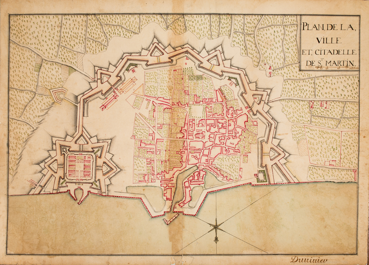
“Plan, de la, Ville et, Citadelle de St. Martin.” Watercolor, pen and ink, [17–]. Map Division, Maps 8-N-3.
Like most European cities, St. Martin de Ré, located on the Ile de Ré in western France, was protected by extensive fortifications. Vauban constructed them in phases between the 1670s and 1702. The large “eared” bastions were of an earlier style but were strengthened by more modern forms of outworks. The citadel (lower left) provided a stronghold and position of last resort for the garrison.

Sébastien Le Prestre de Vauban (1633-1707), Manière de Fortifier de Mr. de Vauban(Amsterdam, 1689). Book Division, C2 1689 Va.
Vauban at first recorded his system of fortification informally, but by the late 17th century it had been published, accompanied by plates illustrating the proper manner of constructing a fortress. During his career Vauban rebuilt some sixty fortresses, providing France with a defensive shield on its vulnerable frontiers. In his other writings Vauban counseled how to besiege and capture the same sort of fortification.
Sébastien Le Prestre de Vauban (1633-1707), The New Method of Fortification, As Practiced by Monsieur de Vauban, Engineer-General of France, Together with a New Treatise of Geometry (London, 1722). Book Division, C2 1722 Va.
Vauban’s methods were disseminated across Europe through the publication of his treatises in different languages. By the 18th century, besieging and defending engineers were literally reading out of opposite ends of the same text. This English-language edition begins with a treatise on geometry, the critical skill needed to design effective fortifications—or to besiege them.


Pierre Panseron (b. 1736). Etude pour le lavis ou il est fait mention du mélange & de l’emploi des couleurs dans les plans de fortifications & les cartes topographiques. (Paris, ca. 1781). Colored, copperplate engraving. Map Division, Maps 8-N-7a.
Just as the methods of fortifying a place were imported to the Americas from Europe, so too were the conventions of drawing and coloring plans of these structures. Most of the images displayed in this exhibit conform to standard practices of rendering details and of coloring (see Fort Johnston in Case #4).
Sometime around 1781 former drawing instructor and landscape architect Pierre Panseron produced this imaginary fortified town and landscape to summarize accepted techniques for drawing and coloring certain architectural and topographical features.