 |
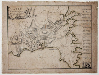
| Warin. Carte de la prise de la Grenade par Mr. Cmte. D’Estaing. le 5 Juillet 1779. |
The Map Division of the Clements Library has recently acquired a rare Revolutionary War-era manuscript map of Grenada in the West Indies. This battle plan may provide the only contemporary visual record of the first phase of the battle for Granada between French and British forces during the American Revolution. It depicts the events on July 2, 1779, when 2,500 French troops attacked the British forces on Grenada, . Other early maps of the engagement record only the second phase, a large scale naval battle on July 6, 1779.
This map, drawn only a few days after the events it depicts, is a precise and elegant work of cartography. The numbered legend on the right provides a roughly chronological sequence of the action, keyed by numbers to the plan. Roads, topography, dwellings, and other details are noted on the map. This is a unique and significant addition to the Clements Library’s collection of manuscript Revolutionary War maps.
