 |
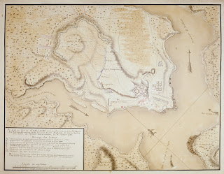
| Michel Chartier de Lotbinière’s “Plan du Fort de Carillon . . . .” (1758) |
Brian Leigh Dunnigan has served as Curator of Maps since 1996 and Clements Library Associate Director from 2010. Having come from a history and historic site museum background, he has a particular fondness for eighteenth-century manuscript maps or plans that include architecture or events. The Clements collection is rich in such documents, many from major manuscript collections such as the Clinton and Gage papers.
One particular favorite dates to a bit earlier—the Seven Years’ War (usually known in the U.S. as the French & Indian War). French colonial engineer Michel Chartier de Lotbinière’s “Plan du Fort de Carillon . . . .” records the spectacular victory in July 1758 of a greatly outnumbered French army over their British opponents at the place usually known as Ticonderoga. The map includes several appealing elements: topography, detailed military architecture, and historical action in its rendering of the defending French troops and the British units that bravely but futilely threw themselves against the fortifications.
The map also has interesting context and provenance. This is not Lotbinière’s original drawing but a copy of his composition probably made by a British draftsman or engineer. A note at the bottom of the title block states, in English, that the original was captured at Québec in 1759 with Lotbinière’s papers. This copy was apparently made for British General Jeffery Amherst for it was once a part of his map collection and was passed down through his family. The Clements purchased the map in 1967.
