Guest post by Cheney Schopieray, Assistant Curator of Manuscripts
On January 26, 1837, Michigan became the 26th state of the Union.
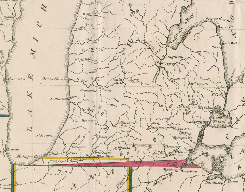 |
| This detail from David Burr’s Map of the Northern Parts of Ohio, Indiana And Illinois With Michigan And That Part of the Ouisconsin Territory Lying East of the Mississippi River (Washington, 1836) shows the disputed Toledo Strip. |
Michigan’s statehood would have been established earlier, were it not for the territory’s disputed southern border. The designated border of Michigan Territory was to be an east-west line drawn from the southernmost point of Lake Michigan. Unfortunately, maps used to describe the proposed border in the 1787 Northwest Ordnance and during Ohio’s 1802 constitutional discussions (such as John Mitchell’s Map of the British and French Dominions in North America) erroneously depicted Lake Michigan’s southern shore as further north. Ohio delegates suspected this inaccuracy and adjusted their constitution to describe their northern border as a line angled from Lake Michigan’s southern point to land north of Maumee Bay.
Congress established the southern border of Michigan Territory in 1805, according to the language of the 1787 Northwest Ordnance. Official survey lines conducted by William Harris (Ohio, 1802) and John Fulton (Michigan, 1818) showed a discrepancy of nearly 500 square miles, claimed by both Ohio and Michigan Territory. The most important factor in the land dispute was state ownership of the mouth of the Maumee River and the nearby town of Toledo. As the proposed end of the Erie Canal and because of its close proximity to the waterways of the Great Lakes, Toledo was especially desirable real estate. The “Toledo Strip” became a contentious issue when Michigan Territory attempted to gain statehood in 1835. Michiganians and Ohioans argued bitterly over the Toledo Strip nearly to the point of violence.
 |
| Stevens T. Mason ALS to Lewis Cass; April 18, 1835. Detroit, Michigan Territory. From the Lewis Cass Papers. |
In April 1835, Stevens T. Mason wrote a letter to Lewis Cass (former Michigan Territory governor, then U.S. Secretary of War under Andrew Jackson) explaining that he would resign his own position as Secretary of Michigan Territory if the Federal government recognized the border established in the Ohio constitution. Although Jackson removed Mason from his post, Michigan Territorial residents voted him Governor in October 1835. In 1837, Mason accepted the U.S. Congress proposal that Michigan would gain the Upper Peninsula in exchange for the Toledo Strip.
 |
| Postal cancellation for “Toledo, M[ichigan] T[erritory],” January 19, 1836. From the Lucius Lyon Papers. |
 |
| The Toledo Strip included several established towns, including Manhattan, Whiteford, and Tremainsville. This Tremainsville manuscript postal marking, dated January 18, 1837, shows an Ohio designation although the town was not officially relinquished by Michigan Territory until it gained statehood. From the Postal History Collection. |
Where does the name Michigan come from?
According to the Michigan.gov website, the name was derived from the Ojibwa word "Michigamaa," meaning "large lake" or "great lake." Here is a link to some interesting facts about Michigan: http://www.michigan.gov/documents/hal_lm_MiB_156795_7.pdf