This is part two of a two part series. Read part one here.
Who was Ferdinand Verbiest and why did he create a world map?
")
Statue of Ferdinand Verbiest in his hometown of Pittem, Belgium. Encyclopedia Brittanica online.
Ferdinand Verbiest was born in 1623 to an educated family in Pittem, a small village outside Bruges in what is now Belgium but what was then part of the Southern Netherlands, ruled at the time by the Spanish branch of the Hapsburg family. Verbiest attended Jesuit schools and entered the order in 1641 with a goal of serving as a missionary somewhere in the Americas. After studying and teaching in Rome, Seville, and Lisbon, he was sent to China instead; because of his abilities in mathematics, his mission called for less proselytizing and more work as the assistant to the ailing astronomer Father Johann Adam Schall von Bell, S.J., (1591-1666) who served as the Director of the observatory in Beijing and head of the Tribunal of Mathematics, with responsibility to establish the calendar each year.
")
dam Schall von Bell, S.J. (1591-1666) with his various instruments used in his role as director of the Observatory: armillary sphere, celestial globe, astrolabe, map on the table, double hemisphere map of the world on the wall. From Athanasius Kircher, Tooneel van China (Dutch translation of China Illustrata) 1668. Source: Wikipedia
At the time of Verbiest’s arrival in China, in 1658, the political situation continued to be unsettled. The ruling Ming dynasty had been defeated in many provinces by the northern Manchu, who were establishing themselves as rulers as the Qing dynasty. Their hold on power was consolidated in the north from 1644 but was more tenuous in the south. Jesuit missionaries throughout the Chinese provinces met the challenge of political allegiance and obedience with varying degrees of deference and/or defiance. Most of the Jesuits were viewed with suspicion by the new rulers unless their intellectual or scientific abilities were deemed valuable. Such was the case of the Beijing Observatory where the establishment of the yearly calendar, a vital resource for life in the empire, was a primary function of the court astronomers, because the calendar determined auspicious and inauspicious dates for all life’s (and death’s) activities, and predicted phases of the moon, eclipses, and other celestial phenomena that affected administrative and agricultural planning. To create an accurate calendar, the expertise and know-how of European-trained Jesuits was valued, even though their missionary goals were distrusted.
After a short period of introduction to the Chinese language and to the Jesuit organization in China, Verbiest arrived in Beijing in 1660 to find Father Schall in deep trouble, accused of incompetence and sedition for having predicted the wrong days and times for several royal funerals and for following a religion that set itself against the Chinese empire. The charges emanated from the political maneuverings at the royal court where the power of the very young Kangxi Emperor (1654–1722, reigned 1661-1722) was assumed by four regents who fomented intrigue and power brokering. In a move of suppression, the regents exiled most of the Jesuits present in Beijing to Canton (Guangzhou). Four, however, were kept in Beijing, chained and imprisoned: Schall and Verbiest, mathematicians and astronomers, and their elderly colleagues, Father Ludovico Buglio (1606–1682), a Sicilian, and Father Gabriel Magalhaes (1610-1677), Portuguese. Schall’s considerable skills in astronomy threatened the less skilled Chinese mandarins at the Observatory, who were suspicious of the Jesuits’ European style inquiry and observation. They were further convinced that Christian religion was antithetical to Chinese culture and therefore seditious. Their views translated into a death sentence for Schall and continued imprisonment for the others. Fortuitously, an earthquake of sufficient magnitude occurred on the day designated for Schall’s execution; all the prisoners were reprieved. Schall was thus saved from the harsh death sentence of death by a thousand cuts (lingchi), though once free, he succumbed to his own ill health in 1666.
Pardoned but not rehabilitated, Verbiest remained under house arrest with his two colleagues until one of the four regents died in 1667 and the Kangxi Emperor, now 13, exerted full control of his court. He dismissed the remaining three regents upon examination of their skills, but allowed the less than competent Chinese astronomer who had led the accusations against Schall to remain in charge of the Observatory and of the calendar, to his regret. The calendar for 1668 was riddled with errors, causing the length of the year to be in disarray. By Christmas of that year, the emperor sent his mandarins to the Jesuit house for help. Verbiest, with his older colleagues, made a stunning display of predictions of the length of a day based on the sun’s shadow with a gnomon. The accuracy of his predictions was based on the spherical shape of the earth. His success resulted in the emperor’s invitation to take charge of the Observatory and the calendar in 1669. (Bosmans, 1912; Golvers 1993)
The demonstration of the sun’s shadow was followed by the presentation of a book to Kangxi Emperor in May of 1669, the Yulan xifang yaoji 御覽西方要紀 (A Record of the Essentials of the West, for the Emperor’s Inspection, 1669), a geographical account of the European west, prepared by Verbiest, Buglio, and Magalhaes during their house arrest. Soon after, Verbiest and his colleagues prepared models of instruments for the observatory and the world map in both large and small versions. The curious young monarch, fascinated by these creations, requested a series of special private lessons to learn more European mathematics and astronomy. Verbiest describes these private encounters in Chapter 12 of his Astronomia Europeana… revocata, posthumously published in Europe in 1687. The Latin text and its earlier Chinese versions also recount in detail the creation and operation of six magnificent astronomical instruments for the Observatory in the early 1670s, to better observe and predict celestial phenomena.
")
“Specula astroptica Pekinensis juxta exemplar ex China missum”: The roof of the Beijing Observatory with the six astronomical instruments designed by Ferdinand Verbiest. In Verbiest, Astronomia Europaea sub imperatore Tartaro Sinico Cam Hy appellato ex umbra in lucem revocata…, Dilingen, 1687. Facing last page of the Praefatio. University of Michigan, Special Collections, QB 17 .V48 1687 .
")
The view of the roof of the Observatory in Beijing shows the six astronomical instruments, designed and produced by Verbiest and his colleagues Buglio and Magalhaes The instruments are, clockwise, sextant, quadrant, altitude azimuth, equatorial armillary sphere, a celestial globe, ecliptic armillary sphere. From J. B. du Halde’s Description géographique, historique, chronologique, politique, et physique de l’empire de la Chine … La Haye, 1736. Volume 3, page 340. Clements Library: C2 1736 Du.
")
Beijing Observatory with Verbiest’s instruments still in situ. (Image from Unesco, Portal to Heritage Astronomy. https://www3.astronomicalheritage.net/index.php/show-entity?identity=18&idsubentity=1today
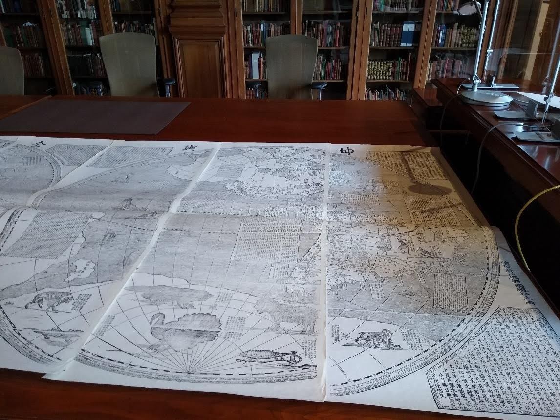
Making the map(s)
The Kunyu quantu, the world map would have provided an excellent backdrop and visual aide to Kangxi Emperor’s private instruction on cosmography and geography. In one of the manuscript editions of the Astronomia, Verbiest describes how the map was created along with the six new astronomical instruments for the Observatory: “Moreover, I published two maps of the earth, on large and one small, together with an explanation of the most important matters which are related to the sublunar world, and two stellar maps, each with its proper horizon and its hour circle, similar to an astrolabe.” (Astronomiae apud Sinas Restitutae Mechanica Centum et Sex Figuris Adumbrata =The Mechanics of the Restored Astronomy in China, delineated in 106 figures, translated in Golvers and Nicolaides, ed., 2009, 167.)
The “large map” mentioned by Verbiest is doubtless the eight-sheet world map of 1674; the small map is of the same year, a double hemisphere map with accompanying text printed on one sheet. Two versions of the small map are found in Paris in the Bibliothèque nationale de France (GE C- 5358 RES) and in Venice in the Biblioteca Marciana. Verbiest used these printed maps not only for the lessons with the young emperor but also sent them to fellow Jesuits and to foreign visitors, such as the Russian emissary to Beijing, Nicolas Spathary.
The sources Verbiest drew upon for the texts, the geography, and the illustrations of the map may be found in the various works of European geographers, European Jesuits active in China, and Chinese geographers. Some scholars (e.g., Walravens 1991) have suggested that a source might be the large (7 x 10 feet) double hemisphere wall map of the world, Nova totius terrarum orbis tabula, first published by Joan Blaeu in Amsterdam in 1648. (A recently restored copy of the Blaeu map at the University of Texas may be seen digitally.) The second edition of the Blaeu map of 1655 matches the Kunyu quantu 坤輿全圖 in size and content for China, as Blaeu was able to draw upon the on-site work of Martino Martini, S.J., whose Novus Atlas Sinensis Blaeu published in 1655. Verbiest had traveled with Martini to China and certainly consulted Martini’s maps from the Novus Atlas Sinensis, as attested in his correspondence (Verbiest 2017). Whether Martini also brought other Blaeu maps with him to China is not known but possible. There is no extant evidence of the large Blaeu map being present in the Jesuit libraries in Beijing at the time of Verbiest’s work, yet it might be possible that the Jesuit team used a pantograph to enlarge map(s) already in their libraries to the size of the Kunyu quantu. (The presence of a pantograph is recorded in correspondence between Verbiest and a Jesuit colleague in 1670. Golvers 1993, 117, 300)
The artistic skills of Buglio for the drawings on the map (animals, ships) and the mechanical expertise of Magalhaes could also have contributed to the design and execution of the large map and its printing. As Verbiest pointed out to a friend and fellow Jesuit, although he is named the sole Director of Mathematics for the Observatory, his work was in fact the work of all three Jesuits. (Bosmans, 1912, 381-383). When he signed, he signed for all three.
Later editions of the Kunyu quantu 坤輿全圖 (Complete map of the world)
The Kunyu quantu 坤輿全圖 continued to arouse Chinese interest. A copy of the map was reprinted from the 1674 woodblocks in Canton/Guangzhou in 1856, with a new colophon added to the existing colophon on the right (western) hemisphere, inscribing a new date and place, as may be seen on the copy in the National Museum in Seoul. Korean interest in the Verbiest world map spurred the cutting of new woodblocks in Seoul in 1860. The new blocks were slightly smaller than the original, though the title and the contents remained unchanged. The frames around the eight texts on the two side panels remained in the European baroque style, but the texts of the six interior cartouches were compressed into four squared off corner cartouches surrounding the two hemispheres. Many institutions have copies of the printing from the 1860 woodblocks, both with and without the two side panels. Some copies are beautifully colored, as this one mounted on a screen in the Musée Guimet in Paris

Eastern hemisphere from the Kun yu quan tu, printed from woodblocks recut in Seoul, Korea in 1860. Musée Guimet, Paris. https://www.guimet.fr/blog/focus-sur-des-tresors-cartographiques
Or this vibrantly colored copy in the Osher Map Library, University of Southern Maine and a similarly colored copy in Macalester College, St. Paul, Minnesota.

Caption: Ferdinand Verbiest, Kunyu quantu, eastern hemisphere, comprising Europe and Asia, printed from wood blocks cut in 1860 in Seoul. Osher Map Library, University of Southern Maine. : https://oshermaps.org/map/13106.0001
The Korean woodblocks still exist, housed in the National University Museum of Seoul; they were printed again in the 1930s in six sheets, without the two side panels. In the 1990s, the Clements Library acquired a 1930s reprint in six sheets from the 1860 blocks to serve as a useful and more manageable point of comparison and study for the 1674 Kunyu quantu 坤輿全圖).
Two other Verbiest works found in the Clements Library
The texts of the Kunyu quantu 坤輿全圖 were published separately by Verbiest in book form, entitled Kunyu tushuo 坤輿圖說. The two volumes contain the texts of the fourteen cartouches and the images of the animals on the map as well as the seven wonders of the ancient world, to which are added an image of Rome’s Colosseum. The Clements holds a 1920s reprint of the Kunyu tushuo (C2 19—Ve).
")
Image of the wild turkey from the Kunyu tushuo, Clements Library. C2 19—Ve.
The Special Collections department of the Hatcher Graduate Library holds a copy of Verbiest’s Astronomia Europaea svb imperatore tartaro sinico Cám Hẏ appellato ex umbra in lucem revocata…revocata (1687), which recounts in detail the reestablishment of the Observatory and the construction of the astronomical instruments, providing the context in which the Kunyu quantu 坤輿全圖 was made.
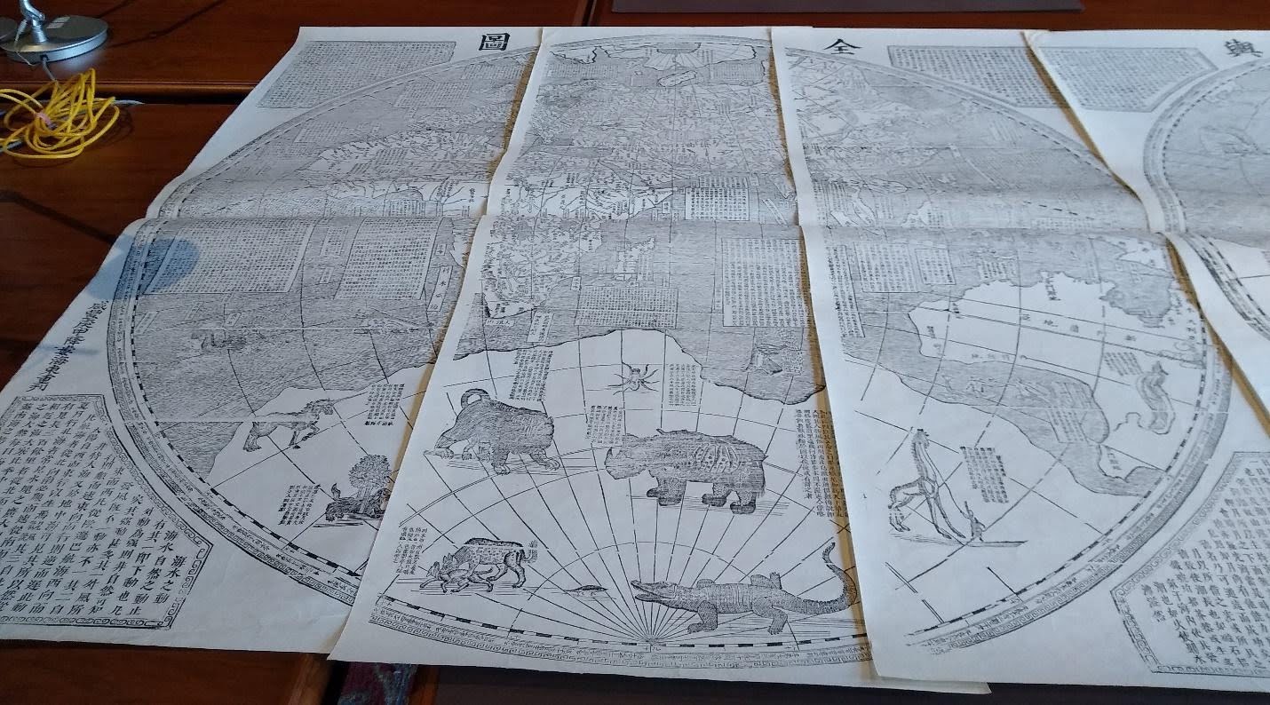
Six sheets of the Kunyu quantu, reprinted in the 1930s from recut wooden blocks created in Seoul Korea in 1860. Clements Library. Digitized Image of the Map
How the map came to the Clements
The map screen was acquired by the library in an unusual way. The only records of its provenance are found in carbon copies of letters written by the interim director of the Library, Colton Storm (map curator from 1942 until 1950, when he stepped into the role of Associate director to help the ailing Randolph Adams). In a letter to L. Carrington Goodrich, professor of Chinese history at Columbia University, who had written about the map in the Geographica Review (July 1938), Storm described the map’s arrival at the Clements: “A few days ago, a friend of this Library carried into the building from his car a six-leaved [sic] screen on which is mounted a copy of this map.” (Storm to Goodrich, January 23, 1953) In a follow up letter to Goodrich, Storm elaborated further: “[The map] has been in this country at least since 1921 or 1922 and has been owned privately in Ypsilanti most of that time. The recent owner, who gave the map to us, rescued it from a horrid fate. He told me that many years ago, it was used as a decoration in a school in Ypsilanti. One day a teacher came to him and asked if it could be used by recovering the surfaces of the screen for a bulletin board. When he told her that he would buy her a bulletin board, the screen was given to him at once. How tragic that would have been!” (Storm to Goodrich, Feb 2, 1953).
How fortunate to have friends like that! As Colton Storm quickly realized, the Kunyu quantu 坤輿全圖 fits well into the Clements Library’s larger collection of world maps, and its unusual rendition of the two American continents incorporated various 17th century ideas about the breadth and shape of these continents. Father Verbiest’s Kunyu quantu 坤輿全圖 (Complete Map of the World) has now been accessioned and cataloged as well as digitized (images available upon request), bringing it out of local obscurity into the light again.
Mary Sponberg Pedley
Adjunct Assistant Curator of Maps
William L Clements Library
The University of Michigan
2024