This is part one of a two part series. Read part two here.

The western hemisphere from the Complete Map of the World (坤輿全圖, Kun yu quan tu) created by Ferdinand Verbiest (Nan Huairen, 南懷仁) for the Kang Xi Emperor of China in 1674.

Staff members Clayton Lewis and Jakob Dopp stand with the 坤舆全图, Kun yu quan tu [Complete Map of the World], 1674, by Ferdinand Verbiest, S.J. (1623–1688). Using both European and Chinese sources, the Flemish missionary Verbiest created this large double hemisphere map of the world surrounded by explanatory texts, printed from woodblocks on bamboo paper in Beijing for the Kangxi Emperor (1654-1722) of the Qing dynasty. The two hemispheres are arranged to place China close to the center of the map, and thus, the world.
Part One: The Map
The Kun yu quan tu (坤舆全图, Complete map of the world) is printed on eight long sheets of bamboo paper, 175 x 25 cm each, which are mounted onto a folding wooden screen, measuring nearly six feet by thirteen feet (175 x 404cm) Presented to the library in 1953 as a gift from an anonymous friend, it was neither accessioned nor catalogued, so has drawn little notice over these many years. As just one of only 20 copies (at last count) of the 1674 map worldwide, its rarity meant it was little studied outside of Jesuit history circles. However, growing interest in Verbiest has generated literature that illuminates the context of the map’s production, the sources of the map’s geography and iconography (especially of its display of remarkable animals), and the content and purpose of the large amount of written information on the map, raising the map’s profile, both literally and figuratively, in the library.

The Clements Library copy of Kun yu quan tu (坤輿全圖 Complete Map of the World), 1674, Ferdinand Verbiest, S.J. Image stitched together from individual images of each frame of the map screen.
Reading the Kun yu quan tu (坤輿全圖 Complete Map of the World)
The map is printed from separate wood blocks assembled in frames for printing on the long sheets of bamboo paper. It is possible to see the long horizontal white lines indicating the space between each wood block.
")

World map in two hemispheres by Father Ferdinand Verbiest, Beijing, 1674. On six scrolls and two scrolls of text. Amsterdam, Scheepvaart Museum: Object S.3847 Image courtesy Diederick Wildeman.
![Detail of the Verbiest map, outside the left [eastern] hemisphere with the following text: 治理曆法極西南懷仁立法](https://clements.umich.edu/wp-content/uploads/2026/04/V7.jpg)
![Detail of the Verbiest map, outside the right [western] hemisphere. Text reads: 康熙甲寅歲日躔娵訾之次](https://clements.umich.edu/wp-content/uploads/2026/04/V8-e1776809711745.jpg)
Slide 1: (outside the left [eastern] hemisphere)
治理曆法極西南懷仁立法 = Zhili lifa Jixi Nan Huairen lifa
Executed by Nan Huairen of the Far West who administers the calendar system
Slide 2: (outside the right [western] hemisphere):
康熙甲寅歲日躔娵訾之次 = Kangxi jiayin sui ri chan juzi zhi ci
[Period] when the sun traverses [the second part of?] Juzi [Feb.-Mar.] of the Jiayin year of the Kangxi reign [1674]
(Translations kindly provided by Professor S E Kile from the Department of Asian Languages and Culture)
The Map
The center six panels of the Kunyu quantu comprise a map of the earth in two hemispheres, drawn on an equatorial stereographic projection. That means that the equator (latitude) is drawn as a straight line across the center of each hemispheres, intersecting a straight line of longitude in each hemisphere. All other longitude and latitude lines are curved. These lines serve as a grid of location. One hemisphere contains Europe, Africa, and Asia, and part of a great southern continent; the other of North and South America, plus more of the great southern continent.
The hemispheres are arranged in reverse from their European order: the “eastern” hemisphere (Europe, Africa, Asia) is placed on the left; the “western” hemisphere (North and South America) on the right. This allows China (circled in red) to seem to be as close to the visual center of the composition as possible on the projection.
")
")
")
")
Detail from the Kunyu quantu showing China in relation to the longitude markings along the equator, with the location of Beijing (yellow) and its equivalent longitude number of 360 (red) highlighted
Latitudes run east to west, numbered in tens from the equator north or south wards and are marked along the inner circle of the border edge of each hemisphere. The middle circle of the border expresses the time of the longest days in summer in the northern hemisphere and the shortest days of winter in the southern hemisphere. The outer circle of the border is a Chinese design, similar to the oval frame around the texts surrounding the hemispheres.
Across both hemispheres runs a curving line showing shows the ecliptic, that is, the apparent route of sun, moon, and planets of the solar system at different times of the year.

Detail of western (right) hemisphere with portion of South America, the equator with longitude numbers, the curved line of the ecliptic, the outer ring of latitude scale, daylight hours, and decorative frame.
The cartouches, illustrations, and texts
Two scrolls frame the map, each filled with four blocks of text surrounded by European Baroque style frames; six further blocks of text are set above and below the hemispheres in oval cartouches framed with Chinese style borders. These units of text and frame on maps are called cartouches. The contents of the fourteen main cartouches which surround the hemispheres and fill the flanking sheets of the map concern particular descriptions of the earth — its sphericity, the elements (air, fire, earth, sky), and the nature of eclipses– , and certain aspects of geography, both physical and human — earthquakes, humankind, rivers, mountains. These were subjects of particular interest to the young Kangxi Emperor, who had asked the Jesuits fathers to teach him the European understanding of the earth and its characteristics.

One of the cartouches from the right side of the map. It describes the division of the globe in 360 degrees and demonstrates how an eclipse occurs, noting that if the Earth were square, the shadow it cast on the moon would not be circular.
To Note:
The Library of Congress also holds a copy of the Verbiest map which was on public display at the San Francisco Asian Art Museum’s 50th anniversary exhibition in 2016. An interactive tool, with the inner descriptive portion translated by University of Michigan student, A. C. Baecker, allows English access to much of the map’s detailed annotation. A current research project funded by the China Center at the University of Michigan supports the further translation of the entire map.
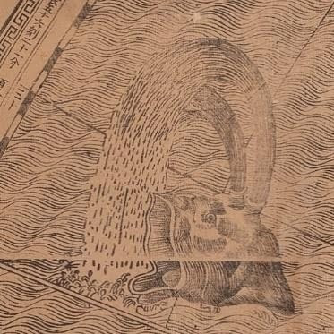
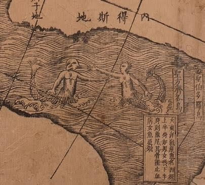
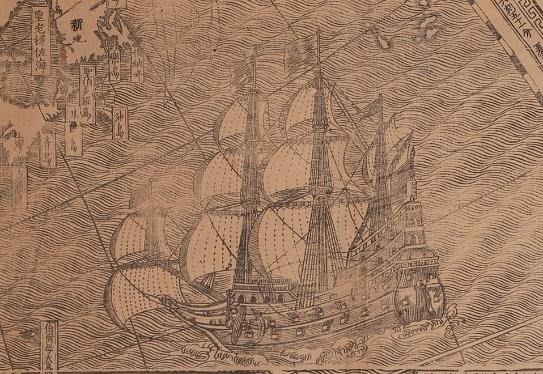
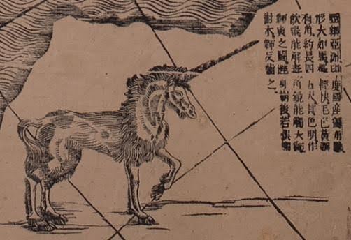
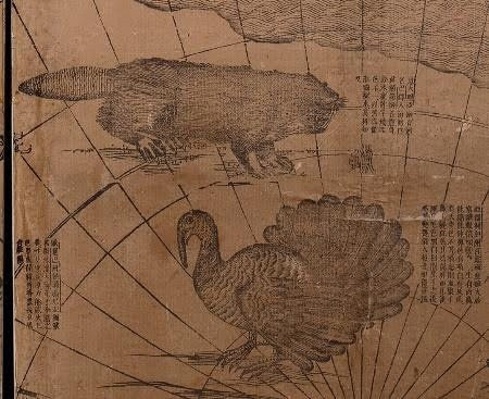
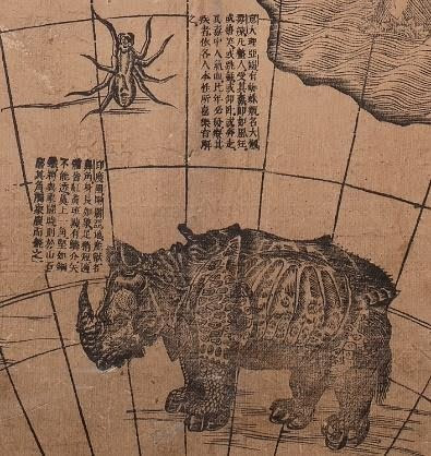
Further blocks of text fill spaces on land and water on the map; they explain places and peoples and the animals which fill the great southern continent (Antarctica). Water is rendered through the use of wavy lines incised from the wood blocks, leaving land masses uninked and rendered as white. Waters are dotted with sea creatures, from the ordinary (whales) to the extraordinary (mermen and mermaids), and ships of various European types (cargo and warships).