By Angel Burns-Hargrove
In this Q&A, Clements Conservator Julie Fremuth and Curator of Maps & Graphics Sierra Laddusaw discuss a significant 1800s map of Texas, Oregon, and California, sharing insights on its historical value and the conservation work that our copy required.
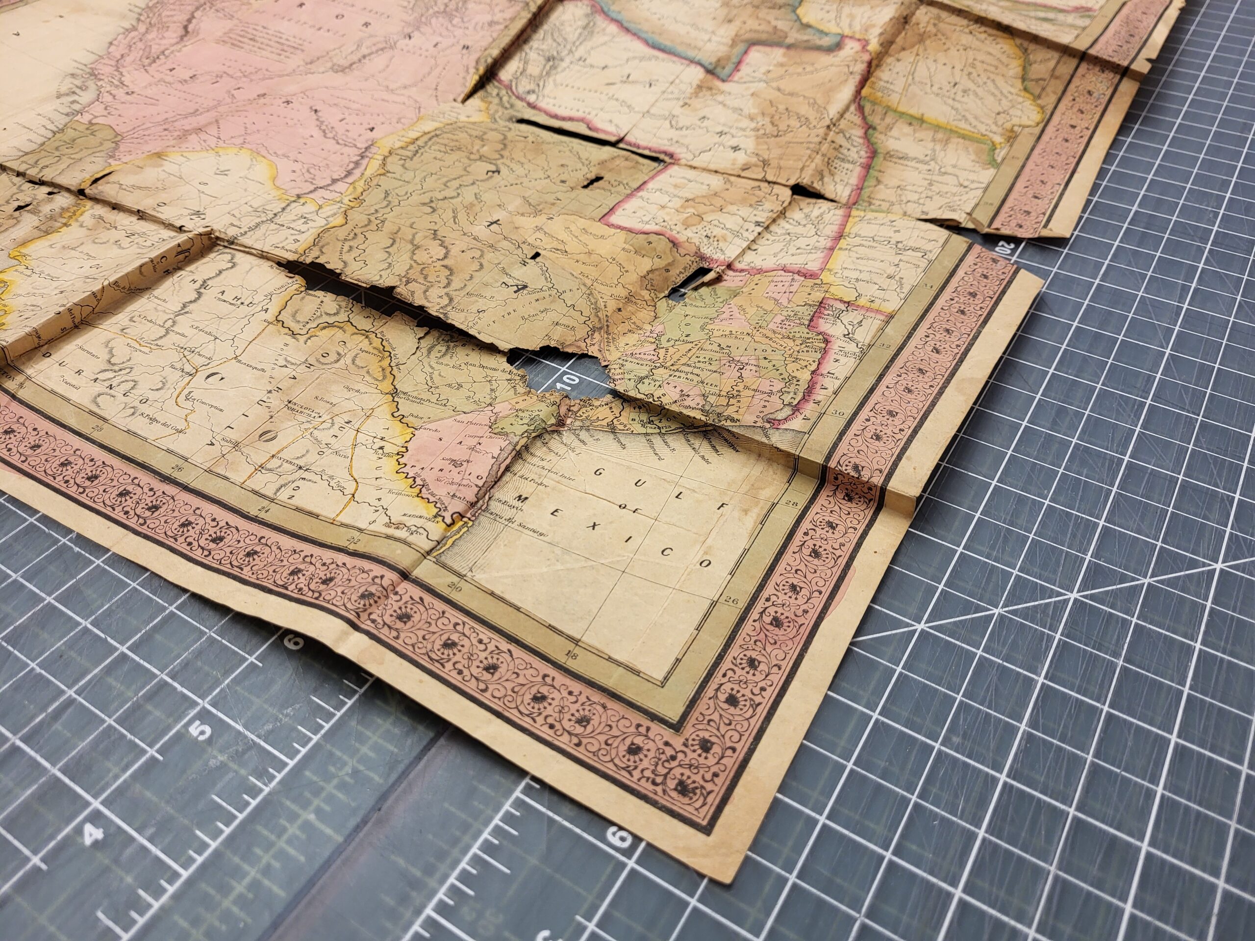

S. Augustus Mitchell’s 1846 A new map of Texas, Oregon and California, before and after conservation.
Could you talk about the significance of the map? What makes it so important to conserve?
Sierra: “A new map of Texas, Oregon and California” was published by S. Augustus Mitchell soon after Texas had been admitted to the Union as a state, which eventually led to the US and Mexico going to war. When you look at this map, you’ll see that Texas appears much larger than we know today. This map was also printed around the time that people were moving West for the Gold Rush and it was used by Mormon pioneers in their move from Missouri to Salt Lake City, Utah.
How does this map help people understand the history of the United States in the mid 1800’s?
Sierra: The map reflects a period when the United States was rapidly expanding. It visually represents Manifest Destiny, the idea that the country was destined to expand westward. You can see tribal names, main migration routes, and the growing transportation networks between cities.
Julie: The information on this map is quite general, so it’s hard to imagine using this map today. Can you imagine not knowing exactly if you’re headed in the right direction? There was no Google Maps or GPS, even an atlas from 1970 would have more information.
Could you walk us through the specific steps you took to conserve the map? What are some of the biggest challenges you faced during the process?
Julie: Anytime I begin treatment on an item, it always starts with a conversation with the curators. The curators can tell me what kind of value the item and its content has, whether it’s monetary, historical, research value, etc., and how the curator anticipates the item will be used. From that information, I can provide a range of treatment recommendations.
I always pay attention to the features of the materials I conserve. What kind of paper is it? When and how was it printed? And then when we look at the color, is it printed or applied by hand?
In the mid-19th century, paper was made from wood pulp fiber and was more acidic and prone to deterioration. To address the various tears, instead of repairing each individual tear, I used one sheet of Japanese paper as a lining material. The map was pressed between interleaving sheets and cotton blotters for about twelve days, which were changed out every few days.
Sierra: This map is often thought of as one of the most important 19th century maps of America, this is due to its popularity and mass production. The paper is low quality to keep the production affordable, which has led to not very many copies surviving. The ones that do exist today either went into private collections early on or got stashed somewhere and didn’t see very much use.
Why was Japanese paper used in this conservation process?
Julie: I use Japanese paper to line fragile materials because it is a very thin supportive paper. It has long fibers that don’t tear easily and acts as a very thin backing paper that can still support the document. When making conservation decisions, I am selecting adhesives and papers based on the attributes that they have and how they’d interact with specific items.
Can you talk us through the decision not to patch the holes found in the map?
Julie: When it comes to the preservation of historical materials, there are different approaches.
Restoration is when you want to return something to its original form.
Conservation is when you repair something focusing on stabilizing the item for future research, retaining signs of past use.
This map has voids – missing chunks of color and information. The voids show part of its use, some of its history. I like to see evidence of someone’s use and interaction with the item. You’re kind of a detective piecing together the story of an item.
Sierra: If you look through the Library’s online catalog for maps, you’ll see that we have a number of facsimile maps in the collection. Before the rise of the internet, you’d have to request photostats copies or have one created while on a research trip. This was the only way to compare various copies of the same map. With digitized collections, there’s less of a need for restoration of a specific chunk of this map. We can look at copies of this same map in other collections to see what is missing from our copy.
Digitizing historical documents is essential for their preservation and accessibility. This accessibility benefits researchers who may not be able to visit libraries in person, giving them the choice to look over materials remotely. Additionally, it gives curators the opportunity to collaborate with other curators from different institutions to reference each other’s findings in a more convenient way.
That’s why we launched an ambitious fundraising campaign—and we’re asking for your help to raise $25,000. Clements Library board members have kicked off the campaign with a 1:1 matching gift for the first $5,000 in donations, providing a springboard for success.
With your support, we can expand digital access to thousands of unique items in our collection, making them freely available online to researchers, educators, students, and history lovers everywhere.

Support the acquisition of a brand new DT Atom for the Clements Digitization Team!
https://heritage-digitaltransitions.com/product-catalog/dt-atom/